WINTER X 2025 IS NOW CLOSED FOR ENTRIES. Entries for Winter X 2026 will open in the new year - save the date: 28/12/2026!
The Winter X A Classic Mid-Winter Trail Challenge...
Inspired by the legendary Winter Cross, the Winter X is a mid-winter trail-running adventure. Set in the scenic Meon Valley, this event follows well-trodden public trails, including the South Downs Way, with some short road sections linking parts of the route.
GENERAL INFO
ENTERING THE EVENT
Entries are now closed for Winter X 2025. Provisional date for 2026 is 28th Dec. 2026.
Entries can be made via SiEntries . You will need to register with SiEntries before being able to enter. The event is capped at 300 walkers/runners across all routes. Entries on SiEntries will close on Mon. 22 December.
Please note: the run will be held under UKA rules. Unfortunately, no dogs may join competitors on the route. Runners must be 16 years of age or over to run the 10km event, 18 years of age or over to run the 30km event, and 20 years of age or over to run the 50km and 70km event.
WHAT YOU GET FOR YOUR ENTRY FEE
- Event T-shirt;
- Event timing;
- Marked course and marshal support;
- Fully stocked checkpoints;
- Post-event food / drink;
- Event memento.
RUN HQ
Run HQ is at Meonstoke Village Hall, Pound Ln, Southampton SO32 3NP. (See map )
BEFORE THE DAY
- Please check your personal/emergency contact details are correct on SiEntries.
- Race numbers can be collected from registration at event HQ on the day.
- Any final details will be posted to this page, and we will send out a reminder e-mail to check this page in the week prior to the event. (Please check junk/spam folders in case).
- Do familiarise yourself with the route you are doing. We will be marking all routes, but doesn't hurt to know what you're letting yourself in for...
ON THE DAY
PRE-START
- There will be parking available South of the Meon Hall on Fry's Lane / Chapel Road – please no parking at the hall itself. Please follow signs for parking and directions from marshalls. The Meon Hall is a 5 minute walk.
- Please register at event HQ, and collect your race number. No entries on the day please!
- Participants will be able to leave bags in the hall. There should be someone in the hall all day, but please don't leave valuables.
- Toilets / showers are available for use at Meonstoke Village Hall.
START
All distances to start and finish at the Meon Hall.
- There will be no mass start, start-times will be staggered.
- 70km event to start from 8am...
- ... then flexible start-times between 08:00 and 10:00 - start when you like!
- Please wait for a marshall to set you off.
DURING THE EVENT
- You must visit every checkpoint on your route.
- Make sure your number is visible throughout.
- Please follow instructions from marshals at all times.
- Take all litter with you and dispose of it in a bin at a checkpoint.
- Be nice...to other runners, volunteers, and other people/animals you meet on the route.
In the event of a medical emergency, please ring the emergency services first then notify event admins if possible. For everything else, please speak with a volunteer or contact event admins, we are there to help. If you decide to retire from the course, please let a marshal know before walking off the route and heading home. If we don't know you have stopped, we will assume you are missing in action and act accordingly!
FINISH
Congrats! You have finished either a 10 / 30 / 50 /70km epic - go you!
We will then invite you to into the hall to collect your memento and grab something to eat. We will have hot food, hot drinks, and homemade cake.
Meonstoke Hall has hot showers available to use.
With many miles in the legs and a belly full of cake, tiredness can set in. If you have a long drive home, please make sure you are fully alert before setting off.
Results will be posted here a few days after the event.
MEDALS ARE OVERRATED...
...so everyone that participates will get a rock instead! Some time ago when Rich (Roly) and I were packing for an 86 mile coast-to-coast hike, I saw a huge rock next to his backpack with a smiley face on it. I asked Rich what it was and he said "...oh that's 'Boris the Rock' ... we're taking him with us". His pack was so heavy that he sometimes had to be pushed up to his feet to get him going!

No-one knows what happened to Boris, but every runner/walker will get a 'mini-Boris', as a memento of the race. Feel free to carry it around with you on your next big run/hike!
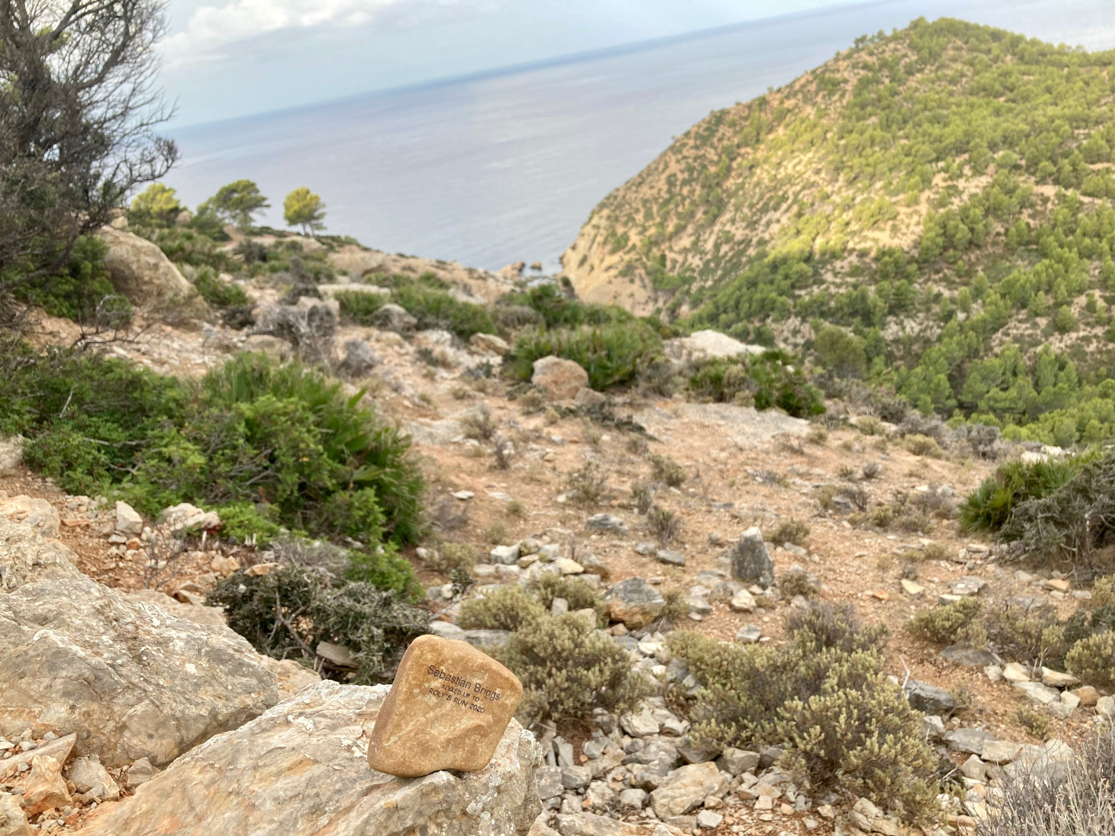
A mini-Boris in Mallorca! (Image courtesy of Seb Briggs)
ROUTE OPTIONS
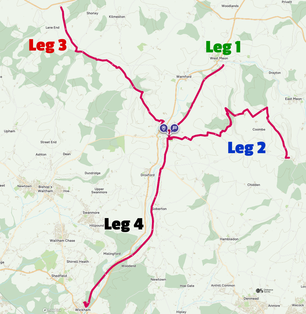
This event will be held on well-trodden public trails, with some road sections to connect them, in and around the Meon valley. The full 70km course consists of four out-and-back legs from Meonstoke, offering runners the choice of four distances:
- 10km — The North leg of the course, flat and steady on the old railway line to West Meon and back;
- 30km — North and East legs. East Leg follows South Downs Way to Sustainability Centre;
- 50km — Takes on the North, East, and West legs. West leg follows South Downs Way to Holden farm via Beacon Hill;
- 70km — The full course, featuring North, East, West, and South legs. The South Leg, as per the first is relatively flat, following the old railway line to Wickham and back to Meon Hall.
Below you'll find a summary of each route, including GPX file and a link to view each route on OS Maps. Please note: GPX files will be updated for the last time a week before the event. Please be aware that the GPX track, while broadly accurate, may deviate from the actual route. Last minute changes to the route are unforeseeable and in this case please follow signage/instructions from marshalls.
SUMMARY:
| Event | Dist. | Climb | Cut-off | Checkpoints | Map/gpx file | Entry fee |
|---|---|---|---|---|---|---|
| 10 | 6.29mile (10.12km) |
77m |
Walkers welcome |
1 | [View in OS Maps]
[Download .GPX] |
£35 (£37 if unattached) |
| 30 | 19.9mile (32.1km) |
499m |
Walkers welcome |
3 | [View in OS Maps]
[Download .GPX] |
£35 (£37 if unattached) |
| 50 | 32.4mile (52.1km) |
832m | 10 hours | 5 | [View in OS Maps]
[Download .GPX] |
£55 (£57 if unattached) |
| 70 | 45.5mile (73.3km) |
935m | 10 hours | 7 | [View in OS Maps]
[Download .GPX] |
£55 (£57 if unattached) |
(*)
CHECKPOINTS
Below is a list of the checkpoints available in each route (please click on the relevant button). Most checkpoints will have a selection of things available including water, snacks and vegan/dairy-free items.
Please follow the marshals instructions when approaching and using the checkpoint facilities. At the checkpoints, marshals will be crossing you off a list / recording the time, to aid with runner tracking.
← Click to expand
70km
| Checkpoint | Leg Dist. (km) | Cum. Dist. (km) | Cold/Hot Drinks | Food | Toilets | Notes |
|---|---|---|---|---|---|---|
| START | 0 | 0 | Y | Toilets at Meon Hall. | ||
| West Meon trail head (turnaround point) | 4.9 | 4.9 | Y/N | Y | N | Small checkpoint. |
| Meon Hall | 5.22 | 10.12 | Y/Y | Y | Y | |
| Sustainability Centre | 10.8 | 20.6 | Y/N | Y | Y | Toilets a short walk from CP. |
| Meon Hall | 10.8 | 31.5 | Y/Y | Y | Y | |
| Holden Farm | 10.3 | 41.8 | Y/N | Y | N | |
| Meon Hall | 10.3 | 52.0 | Y/Y | Y | Y | |
| Wickham trail head (turnaround point) | 10.2 | 62.1 | Y/N | Y | N | |
| FINISH | 10.2 | 72.4 | Y/Y | Y | Y |
(*)
50km
| Checkpoint | Leg Dist. (km) | Cum. Dist. (km) | Cold/Hot Drinks | Food | Toilets | Notes |
|---|---|---|---|---|---|---|
| START | 0 | 0 | Y | Toilets at Meon Hall. | ||
| West Meon trail head (turnaround point) | 4.9 | 4.9 | Y/N | Y | N | Small checkpoint. |
| Meon Hall | 4.9 | 9.8 | Y/Y | Y | Y | |
| Sustainability Centre | 10.8 | 20.6 | Y/N | Y | Y | Toilets a short walk from CP.* |
| Meon Hall | 10.8 | 31.5 | Y/Y | Y | Y | |
| Holden Farm | 10.3 | 41.8 | Y/N | Y | N | |
| FINISH - Meon Hall | 10.3 | 52.1 | Y/Y | Y | Y |
30km
| Checkpoint | Leg Dist. (km) | Cum. Dist. (km) | Cold/Hot Drinks | Food | Toilets | Notes |
|---|---|---|---|---|---|---|
| START | 0 | 0 | Y | Toilets at Meon Hall. | ||
| West Meon trail head (turnaround point) | 4.9 | 4.9 | Y/N | Y | N | Small checkpoint. |
| Meon Hall | 4.9 | 9.8 | Y/Y | Y | Y | |
| Sustainability Centre | 10.8 | 20.6 | Y/N | Y | Y | Toilets a short walk from CP.* |
| FINISH - Meon Hall | 10.8 | 32.1 | Y/Y | Y | Y | |
10km
| Checkpoint | Leg Dist. (km) | Cum. Dist. (km) | Cold/Hot Drinks | Food | Toilets | Notes |
|---|---|---|---|---|---|---|
| START | 0 | 0 | Y | Toilets at Meon Hall. | ||
| West Meon trail head (turnaround point) | 4.9 | 4.9 | Y/N | Y | N | Small checkpoint. |
| FINISH - Meon Hall | 4.9 | 9.8 | Y/Y | Y | Y |
COURSE MARKING
The entirety of the routes will be marked with arrows and flags as necessary. Markings may be less frequent on some major paths e.g. South Downs Way.
We will do our level best to mark the course thoroughly and will have marshals stationed at key points along the course. However, it is possible for signage to be moved/tampered with. Please keep your wits about you and if on the day you notice that signage has been moved, please alert a marshal ASAP.
We recommend that you familiarise yourself with the route and/or have a map of the course/gpx file available on your phone in case (see below in 'recommended kit').
Livestock: There are likely to be some cows just after Old Winchester Hill, when going through the Whitewool farm. Please see 'Walking or running through cattle' .
Please ensure that you close any gates after you.
COURSE CONDITIONS AND RECOMMENDED KIT:
We will keep a close eye on the weather in the run-up to the event. We will take what we're given on the day, except perhaps any named weather systems!
We will NOT be carrying out a kit check. It will be your responsibility to make sure you are equipped for the weather on the day and the likely conditions.
Mandatory equipment:- Mobile phone, fully charged, with event mobile numbers saved. Event admins: 07724393245 (Carlos) or 07888197038 (Simon).
- Head-torch - if going to be out later than 4pm!
- Visible race-number - please ensure your race number is visible to marshalls
Depending on the conditions on the day and distance, any of the following could be advisable:
- Waterproof jacket and trousers.
- Spare warm layer e.g. fleece.
- Visible clothing (try not to look like a ninja).
- A bottle/flask/bladder to carry water (we are trying to go cup-less as much as possible).
- Suitable (comfortable) footwear for muddy/trail conditions.
- Downloading the route GPX onto a watch or phone using an app such as 'Viewranger' or OSMaps.
- Hat/buff.
- Gloves.
- Plastic bag/dry bag to keep stuff dry.
- That favourite food, that they won't have at the checkpoints...to cheer you up :-).
- A sense of humour!
SPECTATORS
Spectators are welcome at various points on the route. Below is where we'd recommend:
- Start / Finish: Meon Hall, Meonstoke. Please park at the event parking not at the hall itself.
- Winchester Hill (Winchester Hill checkpoint): some parking here.
- Beacon Hill car park: Please approach from Beacon Hill Lane, NOT from Exton.
- The Milbury Pub at Beauworth: Salt Lane, adjacent to South Downs Way (50km / 70km only).
- Wickham: at trail-head by checkpoint, some parking here. (70km only).